In this guide, we showcase some of the best iOS apps available for the iPhone and iPad to help fly your drone safely.
Before flying a drone in the United States, the Federal Aviation Administration (FAA) expects drone enthusiasts to perform what’s called a pre-flight check.
We went over what a pre-flight, mid-flight, and post-flight checklist should look like in a separate post. In today’s piece, we want to recommend some of the best apps you can use to verify your surrounding conditions before sending your drone up to the skies.
These apps not only help ensure your compliance with federal law, both for recreational flights just for fun and commercial flights for hire, but also inform you if you’re authorized to take flight or not. Without further ado, let’s get started.
1. Aloft Air Control
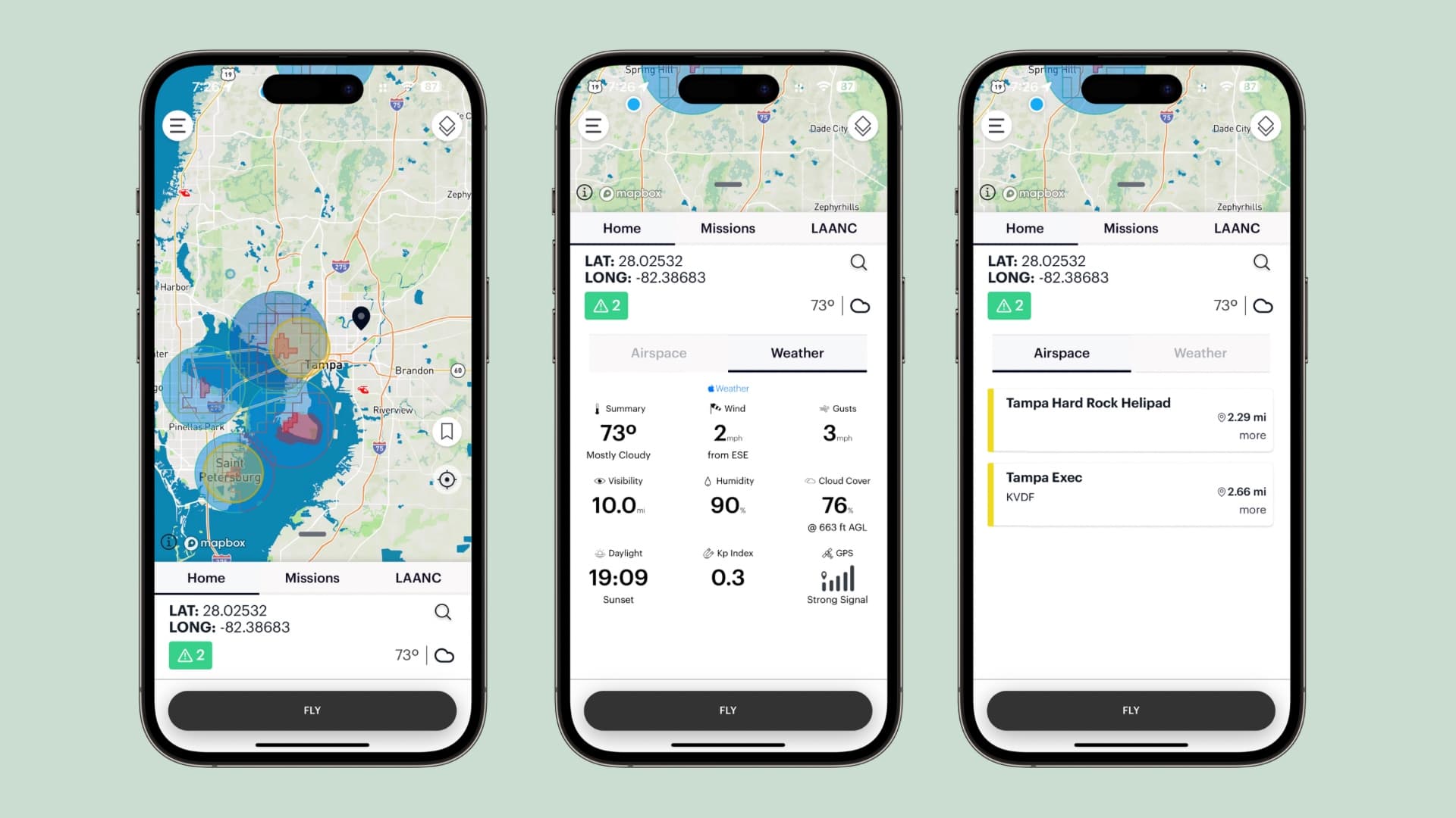
One of my favorite apps to check before ever taking to the skies is Aloft Air Control. It’s almost a one-stop-shop for checking to make sure you’re clear to fly your drone.
Upon launching the app, you can immediately discern if you’re in controlled or uncontrolled airspace, near any hazards such as hospitals, airports, or other sensitive areas that may post a risk to your flight (think low-flying helicopters), and see any temporary flight redirections that may affect the legality of tour flight.
Most of this information is displayed as colored circles on a map. Generally, if the app shows you’re in uncontrolled class G airspace and not inside one of those circles, you’re probably good to go. We said “probably” because there are still a few other things you need to check beforehand.
A small box will appear with green, yellow, or red alerts just below your longitude and latitude to being your attention to any important information before flying. You can also request LAANC authorization to fly in controlled airspace from here.
2. UAV Forecast
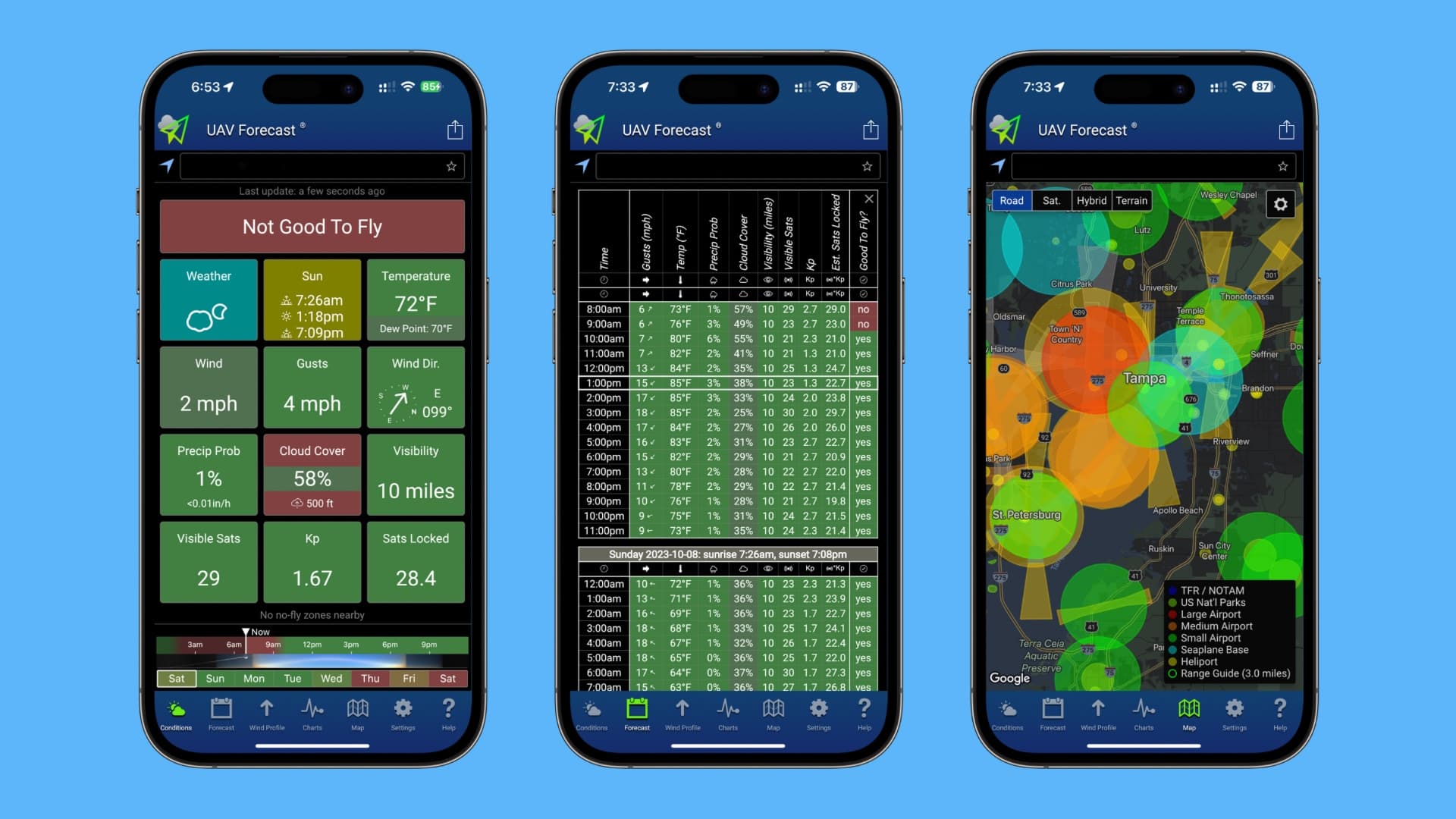
Another one of my favorite apps to check before flying my drone is UAV Forecast, which shows all pertinent weather information drone operators need to be aware of before flying. This includes wind gusts, cloud base height, humidity, Kp, visible and locked satellites, visibility, and sunrise/sunset times, among other things.
The first page displays everything you need to know in a concise manner, making it easy to see if you’re cleared to fly. In the other tabs, you can see future weather reports, view a map to learn about possible nearby safety hazards (again, think about airports, helipads, and other areas you may want to avoid), and see detailed charts.
UAV Forecastis available for free, but I highly recommend at least the cheapest premium subscription to unlock access to more weather information, especially if you’re a drone operator who’s making money from using their drone.
3. StationWeather

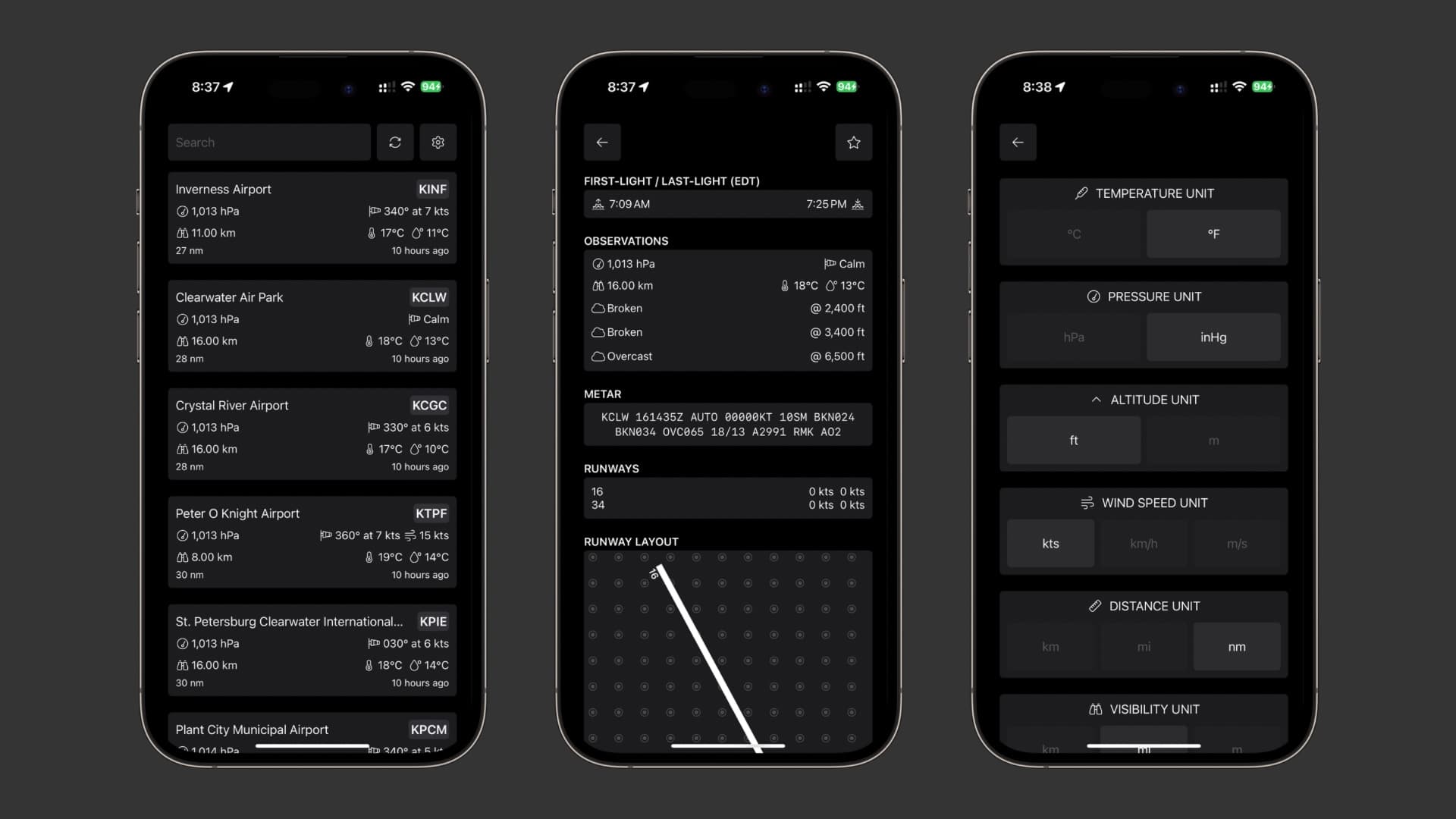
Adding to situational awareness, the StationWeather app is a powerful tool for checking information issued by nearby airports, which will be especially helpful if you live near controlled airspace. Even if you don’t live near airports, you can use this app to check TAF & METAR weather reports, Notice to Airmen (NOTAMs), view airport runway layouts, and more.
While you might never think that understanding runway layouts would be important for a drone pilot, that’s not the case. In fact, when you study for your Part 107 license, this is something the FAA wants you to know. It’s important to understand how airport traffic patterns work so that you’ll know where aircraft come and go from, so you’re not in the way when an airplane tries to land or take off from the runway.
StationWeather also brings handy utilities that actual airplane pilots would find useful, including unit, time, and pressure/density altitude converters.
You can get StationWeather for free. The app provides in-app purchases to unlock powerful pro-oriented features that you may find especially handy as a drone pilot.
The developer was gracious enough to offer our readers the IDBLOG coupon code (redeemable via this link) which provides 40% off a subscription for the first year.
4. Sunrise Sunset Times & Widget

The FAA wants you to be equipped with anti-collision lighting whenever you take to the skies at night or during civil twilight, which is either 30 minutes before the Sun rises or 30 minutes after the Sun sets. Therefore, keep a close eye on when sunrise and sunset will be for your area.
There are many apps – even Apple’s own Weather app – for checking sunrise/sunset times, but Sunrise Sunset Times is a great option. It’s got a beautiful user interface with no other distractions, and tells you exactly when those special moments will occur in your area. The app also packs a Home Screen widget, something the other ones lack.
Remember to manually factor in the 30 minutes per the FAA’s remote pilot rules. Keep those times in mind to avoid incurring heavy fines if caught flying a drone during sensitive times without anti-collision lighting or any kind of waiver to do so.
Download Sunrise Sunset Widget
5. Flightradar24
Remote pilots are expected to yield to incoming manned aircraft such as helicopters, airplanes, and even hot air balloons. To help with that, you need some sort of heads-up before the aircraft is already right on top of you. This will give you a chance to move your drone out of the way when applicable.
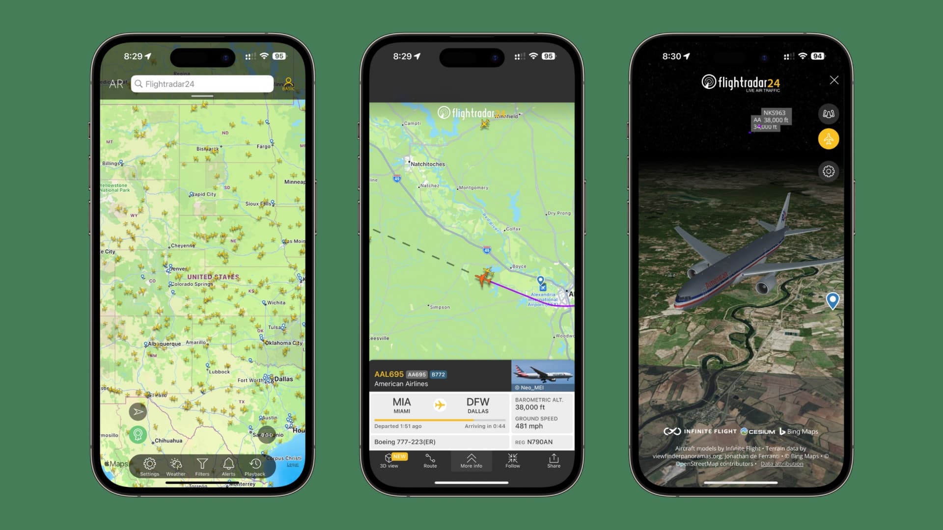
The Flightradar24 app is my favorite way to check for nearby aircraft. IT taps into the ADS-B module on aircraft, which is a GPS-based tracking technology that can provide real-time location information for airplanes, helicopters, and virtually anything else. When you hear an aircraft over your head, you can usually open this app to see what it is.
All this information is public record, so it’s a good idea to tap into this technology to make sure the skies around you are clear before launching your drone up to 400 feet (or higher, under very controlled circumstances such as flying over structures) where other aircraft could be lingering. If you aren’t quick to yield to other manned aircraft, then you can cause what the FAA calls a near-miss, and that’s a big issue that could land you in hot water.
Situational awareness is key to drone flying safety, and this app really helps with that. Even when I’m not flying my drone, I like to use it to learn more about the aircraft in the skies above me. It shows pertinent information, such as the owner, the airline, the type of aircraft, how fast it’s going, its current altitude, and the airport where it took off and where it will be headed next.
6. Drone Scanner

Remote ID is a big deal for drone owners going forward, and you can thank the FAA’s recent regulations for this. Remote IF is a radio broadcast of your drone’s location, its operator’s location, the serial number, your flight telemetry, and a bevy of other information tidbits that could help law enforcement locate a drone owner in the event of an issue that needs investigating.
Drone Scanner is a simple iPhone app that lets you scan your surroundings for nearby Remote ID broadcasts. Why is this important? There are a couple of big reasons you would want to know about Remote ID.
The first, and perhaps the most obvious, would be to increase your situational awareness by learning if there are any nearby drones in the sky. By scanning for nearby drone Remote ID information, you can quickly determine if there’s any possibility of a mid-air collision with another drone.
The second, and perhaps less obvious, is to check to make sure that your drone is broadcasting a Remote ID signal before you take to the skies. If not, you’ll want to find out why. Pretty soon, you won’t be able to fly your drone without Remote ID without breaking Federal Law in the United States. With that in mind, you’ll want to make sure it’s working properly to remain compliant.
Please note that Drone Scanner can’t detect DJI drones on the iPhone due to a Wi-Fi restriction on Apple devices. The app works best on Android handsets.
7. METAR
Being able to read abbreviated weather reports, such as TAF and METAR reports, is just one of the things that the FAA wants all drone operators to be capable of. The free METAR app can help you become greatly familiar with METAR reports by allowing you to check the weather in METAR format.
METAR stands for Meteorological Aerodrome Report, and it’s a format that most pilots, including remote pilots, are to become familiar with before getting their license. They show information such as the time the report was made, visibility, weather conditions, wind speed and direction, and miscellaneous remarks, among other things.
The cool thing about the METAR app is that it puts together a list of nearby airports and displays their respective METAR reports. With this information, you can have a better idea of what direction good or bad weather might be forming and plan your drone flights intelligently instead of waiting for bad weather to come to you unexpectedly.
8. AutoPylot For Drones
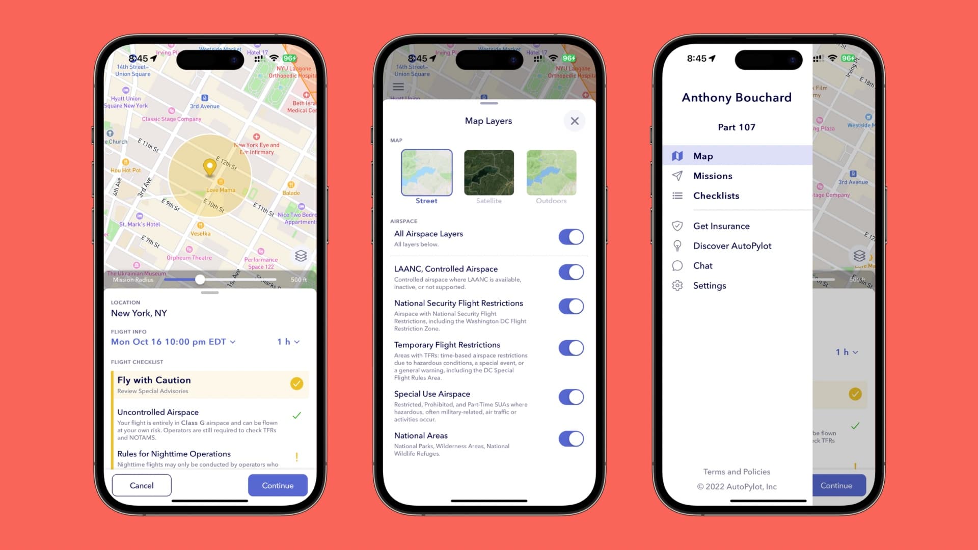
The AutoPylot For Drones app is a lot like the Aloft app discussed above, but it offers a slightly different user interface that some folks may prefer.
With it, you can request LAANC authorization to fly in controlled airspace, document and plan flight missions both for recreation and commercial use, and check to see if there are any temporary flight restrictions near you.
As a general rule of thumb, I like to check more than one app before flying, just in case one app has newer information than any of the others.
9. B4UFLY Drone Airspace Safety

This list wouldn’t be complete without mentioning B4UFLY, an app created in collaboration between Aloft and the FAA for recreational flyers.
Most first-time drone pilots who are flying just for fun can use B4UFLY to check for temporary flight restrictions, controlled airspace, and other conditions. If you’re planning to fly almost exclusively for the sake of flying for fun instead of flying for hire, and you’ve passed the TRUST test, then you can fly under the recreational carve-out known as Section 44809, and the B4UFLY app will satisfy part of your pre-flight check.
You still need to follow the rules of a Community Based Organization (CBO) and check the weather and your own well-being before taking flight.
Wrapping up
Most drone pilots are using some cocktail of apps of their own. Based on my experience, the above apps are some of the most useful for keeping tabs on relevant information that the FAA wants you to check before both recreational and commercial flights. As always, we welcome comments from our readers. If you use a particular app for your drone flight that wasn’t mentioned here, then be sure to let us know why you like it in the comments down below.
More for your drone: